Lêer:CapeHornDetailMap.png

Grootte van hierdie voorskou: 800 × 482 piksels. Ander resolusies: 320 × 193 piksels | 640 × 386 piksels | 906 × 546 piksels.
Oorspronklike lêer (906 × 546 piksels, lêergrootte: 91 KG, MIME-tipe: image/png)
Opsomming
| Beskrywing |
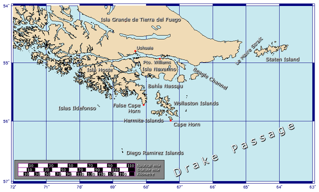
Español: Detalle de las islas cerca del Cabo de Hornos
Generated using GMT. |
| Datum | 27 Januarie 2006 (original upload date) |
| Bron | Eie werk |
| Outeur | Johantheghost |
Lisensiëring
Ek, die outeursreghouer van hierdie werk, publiseer dit onder die volgende lisensie:

|
Toestemming word verleen tot die kopiëring, verspreiding en/of wysiging van hierdie dokument onder die voorwaardes van die GNU-lisensie vir vrye dokumentasie, weergawe 1.2 of enige latere weergawe uitgegee deur die Stigting vir Vrye Sagteware, sonder Invariante Dele, geen Voorbladtekste en geen Agterbladtekste. 'n Kopie van hierdie lisensie is ingesluit in die afdeling getiteld GNU Free Documentation License. |
| Hierdie lêer is gelisensieer onder die Creative Commons Erkenning-Insgelyks Deel 3.0 Onoorgedraagde lisensie. | ||
| ||
| This licensing tag was added to this file as part of the GFDL licensing update. |
This file is licensed under the Creative Commons Attribution-Share Alike 2.5 Generic, 2.0 Generic and 1.0 Generic license.
- U is vry:
- om te deel – die werk kopieer, versprei en deurgee
- om te hermeng – om die werk aan te pas
- Onder die volgende voorwaardes:
- naamsvermelding – U moet die nodige krediet gee, 'n skakel na die lisensie verskaf en aandui of daar veranderinge aangebring is. U mag dit op enige redelike manier doen, maar nie op enige manier wat daarop dui dat die lisensiegewer u of u gebruik onderskryf nie.
- insgelyks – As u die materiaal hermix, transformeer of voortbou, moet u u bydraes versprei onder die dieselfde of versoenbare lisensie as die oorspronklike.
U kan die lisensie van u keuse kies.
Lêergeskiedenis
Klik op die datum/tyd om te sien hoe die lêer destyds gelyk het.
| Datum/Tyd | Duimnael | Dimensies | Gebruiker | Opmerking | |
|---|---|---|---|---|---|
| huidig | 16:17, 21 November 2009 | | 906 × 546 (91 KG) | Botaurus | functionless line (borderline) removed |
| 12:22, 9 Februarie 2006 |  | 906 × 546 (91 KG) | Johantheghost | Less violent colours. | |
| 00:25, 28 Januarie 2006 |  | 906 × 546 (90 KG) | Johantheghost | Fix scale! | |
| 20:20, 27 Januarie 2006 |  | 906 × 546 (87 KG) | Johantheghost | Scale and false cape | |
| 16:34, 27 Januarie 2006 |  | 906 × 546 (81 KG) | Johantheghost | A map showing the location of Cape Horn, including part of the Drake Passage. Generated using [http://gmt.soest.hawaii.edu/ GMT]. |
Lêergebruik
Die volgende bladsy gebruik dié lêer:
Globale lêergebruik
Die volgende ander wiki's gebruik hierdie lêer:
- Gebruik in als.wiki.x.io
- Gebruik in ar.wiki.x.io
- Gebruik in ast.wiki.x.io
- Gebruik in az.wiki.x.io
- Gebruik in be-tarask.wiki.x.io
- Gebruik in be.wiki.x.io
- Gebruik in bg.wiki.x.io
- Gebruik in br.wiki.x.io
- Gebruik in bs.wiki.x.io
- Gebruik in ca.wiki.x.io
- Gebruik in ceb.wiki.x.io
- Gebruik in ckb.wiki.x.io
- Gebruik in cy.wiki.x.io
- Gebruik in da.wiki.x.io
- Gebruik in de.wiki.x.io
- Gebruik in el.wiki.x.io
- Gebruik in en.wiki.x.io
- Gebruik in eo.wiki.x.io
- Gebruik in es.wiki.x.io
- Gebruik in et.wiki.x.io
- Gebruik in eu.wiki.x.io
- Gebruik in fa.wiki.x.io
- Gebruik in fi.wiki.x.io
- Gebruik in frr.wiki.x.io
- Gebruik in fr.wiki.x.io
Wys meer globale gebruik van die lêer.