Lêer:Greece–Turkey land border.svg

Size of this PNG preview of this SVG file: 497 × 600 piksels. Ander resolusies: 199 × 240 piksels | 398 × 480 piksels | 636 × 768 piksels | 848 × 1 024 piksels | 1 697 × 2 048 piksels | 512 × 618 piksels.
Oorspronklike lêer (SVG-lêer, normaalweg 512 × 618 piksels, lêergrootte: 205 KG)
Opsomming
| Beskrywing |
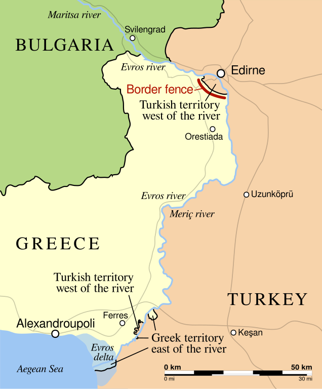
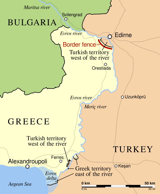
English: The course of the Greece–Turkey land border, mostly following the Maritsa (Turkish: Meriç, Greek: Evros) river (depicted in blue), roughly indicating the 12.5 km border fence (in red) on the Greek side near Edirne, and major highways (in grey). |
| Datum | |
| Bron | Own work based on: Greek Turkish Bulgarian borders and maritsa river.svg |
| Outeur | PanchoS |
| Ander weergawes |
|
| SVG genesis |


Lisensiëring
Ek, die outeursreghouer van hierdie werk, publiseer dit onder die volgende lisensie:
This file is licensed under the Creative Commons Attribution-Share Alike 4.0 International license.
- U is vry:
- om te deel – die werk kopieer, versprei en deurgee
- om te hermeng – om die werk aan te pas
- Onder die volgende voorwaardes:
- naamsvermelding – U moet die nodige krediet gee, 'n skakel na die lisensie verskaf en aandui of daar veranderinge aangebring is. U mag dit op enige redelike manier doen, maar nie op enige manier wat daarop dui dat die lisensiegewer u of u gebruik onderskryf nie.
- insgelyks – As u die materiaal hermix, transformeer of voortbou, moet u u bydraes versprei onder die dieselfde of versoenbare lisensie as die oorspronklike.
Lêergeskiedenis
Klik op die datum/tyd om te sien hoe die lêer destyds gelyk het.
| Datum/Tyd | Duimnael | Dimensies | Gebruiker | Opmerking | |
|---|---|---|---|---|---|
| huidig | 23:58, 19 November 2015 | | 512 × 618 (205 KG) | PanchoS | text converted to paths |
| 23:50, 19 November 2015 |  | 512 × 618 (63 KG) | PanchoS | correct newly introduced typo | |
| 23:45, 19 November 2015 |  | 512 × 618 (63 KG) | PanchoS | a bit more enlarged fonts | |
| 23:10, 19 November 2015 |  | 512 × 618 (67 KG) | PanchoS | improved version: minus incorrect borderline at Aegean coast; slighty larger, more consistent fonts | |
| 19:12, 19 November 2015 |  | 512 × 618 (56 KG) | PanchoS | {{Information |Description ={{en|1=The course of the '''Greece–Turkey land border''', mostly following the '''Maritsa''' (Turkish: '''Meriç''', Greek: '''Evros''') river ''(depicted in blue)'', roughly indicating the 12.5 km... |
Lêergebruik
Die volgende bladsy gebruik dié lêer:
Globale lêergebruik
Die volgende ander wiki's gebruik hierdie lêer:
- Gebruik in ar.wiki.x.io
- Gebruik in ast.wiki.x.io
- Gebruik in ca.wiki.x.io
- Gebruik in ckb.wiki.x.io
- Gebruik in da.wiki.x.io
- Gebruik in de.wiki.x.io
- Gebruik in el.wiki.x.io
- Gebruik in en.wiki.x.io
- Gebruik in fa.wiki.x.io
- Gebruik in ja.wiki.x.io
- Gebruik in pl.wiki.x.io
- Gebruik in tr.wiki.x.io
- Gebruik in zh.wiki.x.io