Lêer:Haiti deforestation.jpg

Grootte van hierdie voorskou: 800 × 600 piksels. Ander resolusies: 320 × 240 piksels | 640 × 480 piksels | 1 024 × 768 piksels | 1 280 × 960 piksels | 2 560 × 1 920 piksels.
Oorspronklike lêer (2 560 × 1 920 piksels, lêergrootte: 1,48 MG, MIME-tipe: image/jpeg)
| Beskrywing |
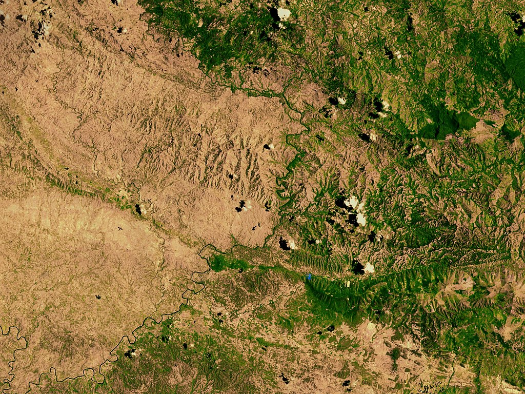
English: Satellite image showing deforestation in Haiti, Haiti-Centre. This image depicts the border between Haiti (left) and the Dominican Republic (right). |
|||||
| Datum | ||||||
| Bron | http://svs.gsfc.nasa.gov/vis/a000000/a002600/a002640/ | |||||
| Outeur | NASA | |||||
| Toestemming (Hergebruik van die lêer) |
|

| Objekligging | | Hierdie en ander beelde in: OpenStreetMap |
|---|
Lêergeskiedenis
Klik op die datum/tyd om te sien hoe die lêer destyds gelyk het.
| Datum/Tyd | Duimnael | Dimensies | Gebruiker | Opmerking | |
|---|---|---|---|---|---|
| huidig | 02:54, 10 Maart 2008 | | 2 560 × 1 920 (1,48 MG) | Calliopejen | {{Information |Description=Satellite image showing deforestation in Haiti. This image depicts the border between Haiti (left) and the Dominican Republic (right). |Source=http://svs.gsfc.nasa.gov/vis/a000000/a002600/a002640/ |Date=2002-09-25 |Author=NASA | |
Lêergebruik
Die volgende bladsy gebruik dié lêer:
Globale lêergebruik
Die volgende ander wiki's gebruik hierdie lêer:
- Gebruik in ar.wiki.x.io
- Gebruik in ast.wiki.x.io
- Gebruik in az.wiki.x.io
- Gebruik in be.wiki.x.io
- Gebruik in cs.wiki.x.io
- Gebruik in de.wiki.x.io
- Gebruik in de.wiktionary.org
- Gebruik in en.wiki.x.io
- Gebruik in en.wikinews.org
- Gebruik in es.wiki.x.io
- Gebruik in eu.wiki.x.io
- Gebruik in fa.wiki.x.io
- Gebruik in fr.wiki.x.io
- Gebruik in fr.wikiversity.org
- Gebruik in ha.wiki.x.io
- Gebruik in ht.wiki.x.io
- Gebruik in ig.wiki.x.io
- Gebruik in kk.wiki.x.io
- Gebruik in la.wiki.x.io
- Gebruik in mk.wiki.x.io
- Gebruik in mt.wiki.x.io
- Gebruik in nn.wiki.x.io
- Gebruik in no.wiki.x.io
- Gebruik in oc.wiki.x.io
- Gebruik in pa.wiki.x.io
Wys meer globale gebruik van die lêer.