Lêer:Shetlandinseln (Landsat).jpg

Oorspronklike lêer (2 986 × 2 986 piksels, lêergrootte: 7,35 MG, MIME-tipe: image/jpeg)
.jpg)
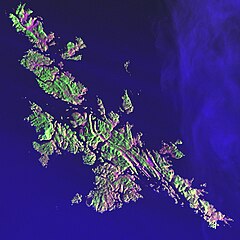
- Svenska: Satellitbild av Shetlandsöarna
- English: Satellite image of the Shetland Islands.
| This file is in the public domain in the United States because it was solely created by NASA. NASA copyright policy states that "NASA material is not protected by copyright unless noted". (See Template:PD-USGov, NASA copyright policy page or JPL Image Use Policy.) | ||
 |
Warnings:
|
From the German Wikipedia
Earth As Art: Shetlandinseln (Landsat)
von: http://landsat.gsfc.nasa.gov/earthasart/shetland.html
Public Domain, Image courtesy of NASA Landsat Project Science Office and USGS EROS Data Center
Shetland Islands Image taken 12/11/2001 by Landsat 7
Like a many-faceted jewel fashioned in an indigo setting, the Shetland Islands lie 210 kilometers north of the Scottish mainland in the North Atlantic Ocean. Despite their 60 degree north latitude, the Shetlands enjoy a relatively temperate climate thanks to the warming influence of the Gulf Stream.
This image can be found on Landsat 7 Path 205 Row 18, center: 60.1 N, 1.2 W.
Bild-Versionen
Legende: (Aktuell) = dies ist das aktuelle Bild, (Löschen) = lösche diese alte Version, (Zurücksetzen) = verwende wieder diese alte Version.
- (Löschen) (Aktuell) 20:40, 30. Mär 2004 . . Srbauer (23305 Byte) (Earth As Art: Shetlandinseln (Landsat))
Lêergeskiedenis
Klik op die datum/tyd om te sien hoe die lêer destyds gelyk het.
| Datum/Tyd | Duimnael | Dimensies | Gebruiker | Opmerking | |
|---|---|---|---|---|---|
| huidig | 00:01, 10 Februarie 2010 | | 2 986 × 2 986 (7,35 MG) | Scewing | Higher Resolution |
| 22:57, 19 Junie 2005 |  | 287 × 287 (23 KG) | Laserpekare~commonswiki |
Lêergebruik
Die volgende bladsy gebruik dié lêer:
Globale lêergebruik
Die volgende ander wiki's gebruik hierdie lêer:
- Gebruik in da.wiki.x.io
- Gebruik in de.wiki.x.io
- Gebruik in fo.wiki.x.io
- Gebruik in fr.wiki.x.io
- Gebruik in la.wiki.x.io
- Gebruik in pl.wiki.x.io
- Gebruik in pl.wiktionary.org
.jpg)