Lêer:Vardar003.png

Grootte van hierdie voorskou: 503 × 600 piksels. Ander resolusies: 201 × 240 piksels | 402 × 480 piksels | 717 × 855 piksels.
Oorspronklike lêer (717 × 855 piksels, lêergrootte: 75 KG, MIME-tipe: image/png)
Opsomming
| Beskrywing |
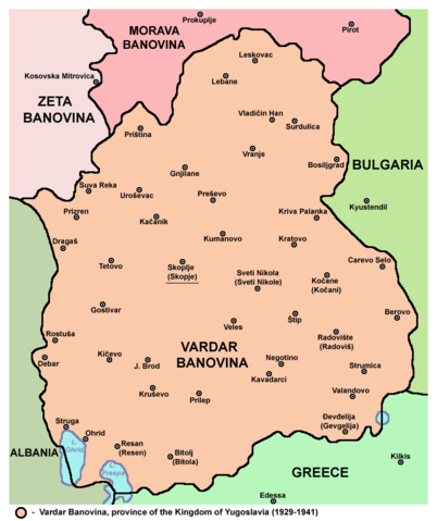
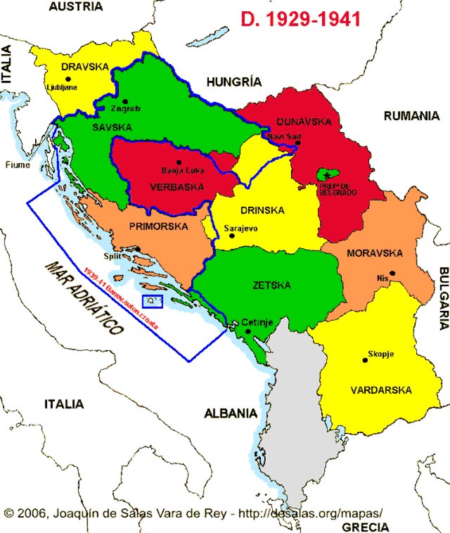
English: Map of the en:Vardar Banovina province of the Kingdom of Yugoslavia (1929-1941). Use with caution because Yugoslav internal borders are not differentiated from the international border. |
| Datum | 11 September 2006 (original upload date) |
| Bron | Transferred from en.wikipedia to Commons by BokicaK using CommonsHelper. |
| Outeur | Original uploader and author was PANONIAN at en.wikipedia |
Lisensiëring
self made map by user:PANONIAN
| This work has been released into the public domain by its author, PANONIAN at Engels Wikipedia. This applies worldwide. In sommige lande is dit dalk nie wettiglik moontlik nie. Indien so: PANONIAN grants anyone the right to use this work for any purpose, without any conditions, unless such conditions are required by law. |
References
- Istorijski atlas, Geokarta, Beograd, 1999.
- Školski istorijski atlas, Zavod za izdavanje udžbenika SR Srbije, Beograd, 1970.
- Denis Šehić - Demir Šehić, Istorijski atlas sveta, Beograd, 2007.
- Povijesni atlas, Učila - Zagreb, Zagreb, 1971.
- Istorijski atlas, Intersistem Kartografija, Beograd, 2010.
- Povijesni atlas za osnovnu školu, Kartografija - Tlos - Zagreb, Zagreb, 1975.
- The Times Atlas svjetske povijesti, Cankarjeva založba, Ljubljana - Zagreb, 1986.
- Dr Tomislav Bogavac, Nestajanje Srba, Niš, 1994.
- Džon R. Lempi, Jugoslavija kao istorija, Beograd, 2004.
- Petrit Imami, Srbi i Albanci kroz vekove, Beograd, 2000.
- Sve srpske mape - od šestog veka do Pariza, Specijalno izdanje BLICA, Decembar 1995
- http://i6.photobucket.com/albums/y226/mindaugas/Maps/banovina.gif (Note: image from Photobucket used only as a secondary reference)
- http://www.hrvatski-vojnik.hr/hrvatski-vojnik/0482005/bpictures/manovina%20Hrvatska.jpg
- http://i252.photobucket.com/albums/hh13/tomba17_photos/Geopoliticke%20zemljovide/KraljevinaJugoslavijaBanovine1929.jpg?t=1242016978 (Note: image from Photobucket used only as a secondary reference)
- http://anamnesis.info/resources/kraljevina_jugoslavija_podela_na_banovine.jpg
- http://www.hic.hr/dom/288/images/pod01.jpg archive copy at the Wayback Machine
- http://forum.net.hr/cfs-filesystemfile.ashx/__key/CommunityServer.Discussions.Components.Files/15/7041.Banovina-b.JPG archive copy at the Wayback Machine
- http://img101.imageshack.us/img101/5218/srezovibanovine.png
- http://bp0.blogger.com/_-JsoJVhpWFY/SH-2oWaqFAI/AAAAAAAAAs4/ElWGFsv5DCs/s1600-h/Vardaska_Banovina.jpg
- http://www.hkv.hr/images/stories/karte/Kraljevina_Jugoslavija_1929_karta.jpg
- http://www.stk-brovinje.hr/povijest/kviz_nacionalni_prvi_drugi/zupanijsko_2008_04_karta_01.jpg
- http://www.euratlas.net/history/hisatlas/balkan_states/194129YG.jpg
Oorspronklike oplaailogboek
The original description page was here. All following user names refer to en.wikipedia.
- 2006-09-11 22:08 PANONIAN 467×546× (22015 bytes)
Lêergeskiedenis
Klik op die datum/tyd om te sien hoe die lêer destyds gelyk het.
| Datum/Tyd | Duimnael | Dimensies | Gebruiker | Opmerking | |
|---|---|---|---|---|---|
| huidig | 10:14, 4 Oktober 2014 | | 717 × 855 (75 KG) | WikiEditor2004 | aesthetics |
| 08:38, 19 Augustus 2011 |  | 718 × 855 (75 KG) | WikiEditor2004 | improved version | |
| 01:40, 17 September 2010 |  | 467 × 546 (21 KG) | File Upload Bot (Magnus Manske) | {{BotMoveToCommons|en.wikipedia|year={{subst:CURRENTYEAR}}|month={{subst:CURRENTMONTHNAME}}|day={{subst:CURRENTDAY}}}} {{Information |Description={{en|Map of the en:South Serbia (Juzna Serbia) (self made) [[:en:Category:Maps of the history of the |
Lêergebruik
Die volgende bladsy gebruik dié lêer:
Globale lêergebruik
Die volgende ander wiki's gebruik hierdie lêer:
- Gebruik in be-tarask.wiki.x.io
- Gebruik in be.wiki.x.io
- Gebruik in bg.wiki.x.io
- Gebruik in bn.wiki.x.io
- Gebruik in bs.wiki.x.io
- Gebruik in ca.wiki.x.io
- Gebruik in da.wiki.x.io
- Gebruik in de.wiki.x.io
- Gebruik in el.wiki.x.io
- Gebruik in en.wiki.x.io
- Gebruik in es.wiki.x.io
- Gebruik in et.wiki.x.io
- Gebruik in fr.wiki.x.io
- Gebruik in he.wiki.x.io
- Gebruik in hr.wiki.x.io
- Gebruik in hy.wiki.x.io
- Gebruik in id.wiki.x.io
- Gebruik in it.wiki.x.io
- Gebruik in ja.wiki.x.io
- Gebruik in ka.wiki.x.io
- Gebruik in lt.wiki.x.io
- Gebruik in nl.wiki.x.io
- Gebruik in pt.wiki.x.io
- Gebruik in ro.wiki.x.io
- Gebruik in ru.wiki.x.io
- Gebruik in sh.wiki.x.io
- Gebruik in sl.wiki.x.io
- Gebruik in sq.wiki.x.io
- Gebruik in su.wiki.x.io
- Gebruik in uk.wiki.x.io
- Gebruik in vi.wiki.x.io
- Gebruik in zh.wiki.x.io